
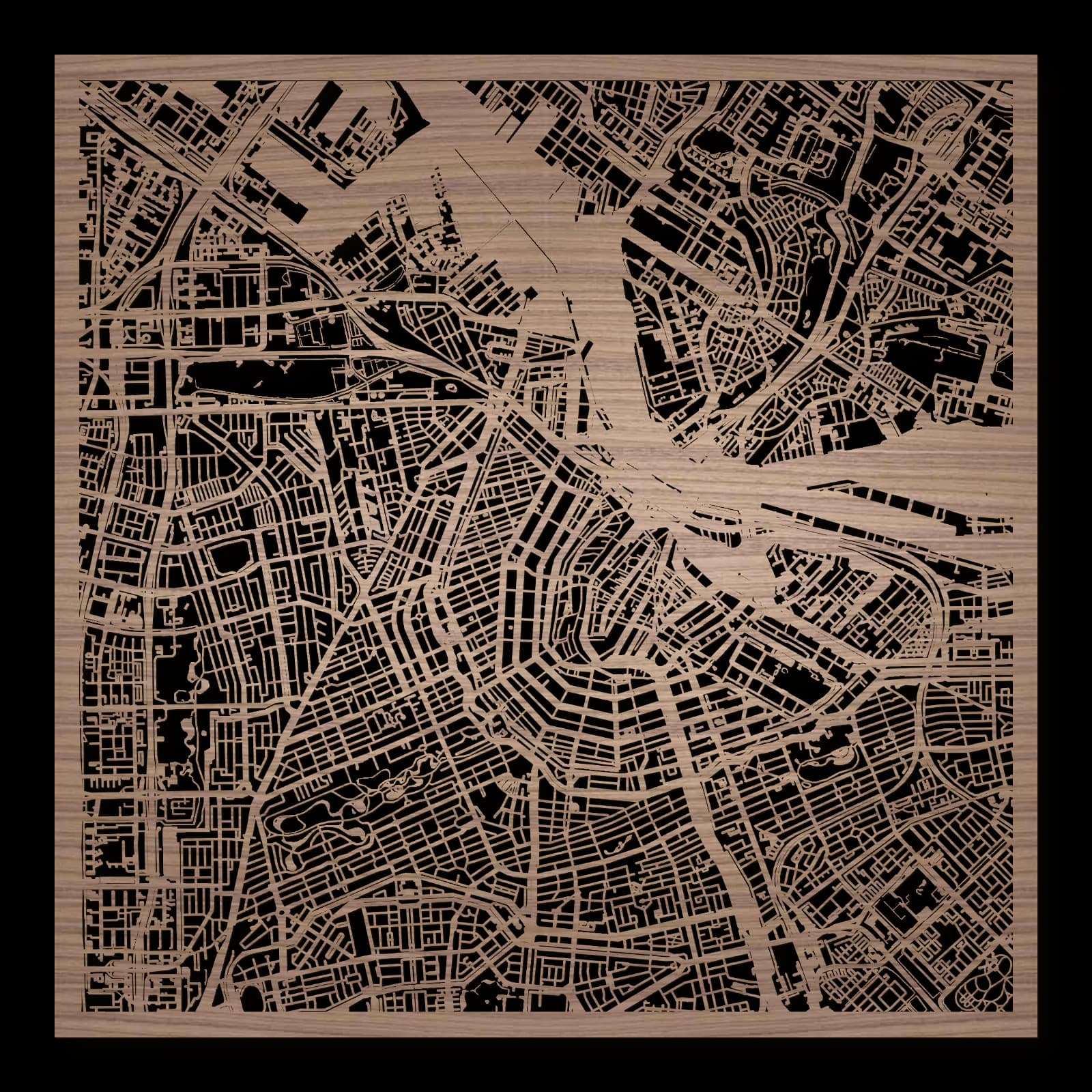
Amsterdam.Canal ring and neighbourhoods around the IJ
Square wooden city map made from oiled walnut.
About the product
Planned canals and a former shipyard give Amsterdam contrasting urban scales. Waterways and streets form a connected wooden city map that also includes neighbourhoods north of the IJ. NDSM, Westerpark, ARTIS and Museumplein introduce spacious working grounds, greenery and cultural places. Their relationships extend the familiar canal landscape into a wider history of urban growth and changing public purposes.
What does the map show?
- Canal ring
- IJ
- Westerpark
- NDSM
- ARTIS
- Museumplein
- Precisely cut and engraved
- Fine laser details with clear depth
- Carefully inspected and securely packed
- Handmade in Germany
Configuration
Shape: Square · Design: Classic · Material: Walnut · Sizes: 23 × 23 cm, 35 × 35 cm, 50 × 50 cm
The configuration shown in the cart and at the time of ordering is authoritative. The preview is not a dimensioned technical drawing.
Availability & production
- Availability
- Made to order
- Production time
- Ships in 3-5 business days
Production starts after successful payment and complete product configuration.
Materials & care
Depending on the variant, lacquered or oiled MDF or oiled real-wood veneer on MDF; optional stainless-steel mounting screws. Acrylic lacquer spray, hard-wax oil and white glue are used in production.
Wood is a natural material. Grain and color may vary slightly from the product images.
Clean with a dry, soft cloth and protect from prolonged moisture and direct heat.
Included & installation
The selected product in the ordered configuration, securely packed and prepared for installation.
- Maximum dimensions 50 × 70 cm and maximum product weight 2 kg.
- Wall-fixing screws and wall plugs are not included. Use fixings suitable for the wall type, substrate and product weight.
- Installation must be carried out by an adult. Keep optional mounting screws and other small parts away from children until installation.
Shipping & returns
Securely packed shipping. Return and cancellation information is available in the legal section.
Shipping costs and delivery options depend on the destination and format. The published cancellation right applies to non-personalised standard goods; it may be excluded for individually made products.
Manufacturer & product identifier
- Manufacturer
- Benjamin Nöst - Lightworks
Rorichmoorer Str. 76
26802 Moormerland, Deutschland
kontakt@lightworks.de - Product identifier
- LW-CAT-683B6F102CC7-S, LW-CAT-683B6F102CC7-M, LW-CAT-683B6F102CC7-L
Together with the order or production batch, the relevant SKU enables traceability. Safety questions and incidents can be reported to the email address shown above.
Product safety
- Decorative product for dry indoor use only; not a toy and not intended for children.
- Protect from moisture, high heat and open flames.
- Do not continue to hang the product after a fall, breakage or visible damage. Keep damaged parts away from children.
Amsterdam’s planned canals and changing urban landscapes
Waterways help explain Amsterdam, together with the neighbourhoods between them. The canal ring represents a major planned expansion, while NDSM shows the later transformation of industrial ground. Westerpark, ARTIS and Museumplein introduce greenery, living collections and culture. The city’s different settings on either side of the IJ consequently operate at more than one spatial scale.
Water within a planned expansion
Amsterdam’s canal ring developed through a major extension of the city in the late sixteenth and early seventeenth centuries. Canals, streets and building plots were planned together as a connected system. Water served practical purposes for transport and drainage as well as shaping the landscape. The curving canal routes expanded the older settlement towards the west and south. Their organisation remains visible in the present city pattern. Repeated relationships between water and built frontage support different streets, houses and public places along individual sections. Large-scale planning and ordinary urban life are closely related within this distinctive structure.
Westerpark and a changing western city
Westerpark’s history belongs to the development of the western districts. A first park was created in 1845 within a growing working neighbourhood; subsequent railway expansion changed the area. Such transitions demonstrate that public greenery is not an unchanging backdrop. It relates to transport, adjacent development and shifting urban purposes. The present Westerpark consequently offers a different historical perspective from the older canal ring. It brings together growth, infrastructure and open space across successive phases of city development. That wider relationship is part of its place in Amsterdam, alongside the immediate experience of a green public landscape.
A former shipyard across the IJ
NDSM occupies former shipyard ground north of the IJ. Cultural use today retains a relationship with a working landscape of large halls and open areas. Its scale differs from the narrower plots associated with the historic canal city. The position beyond the broad water also introduces another urban perspective. NDSM shows how former industrial sites can acquire new roles while their earlier physical character continues to matter. Connections across the IJ bring the area into a larger city relationship. They do not erase the differences in buildings, open ground and historical functions between the two sides.
Collections and shared cultural spaces
ARTIS was founded in 1838 by the society Natura Artis Magistra. It connects Amsterdam with the history of living collections and natural knowledge. Museumplein farther south provides a substantial public space within a district shaped by art and cultural institutions. These locations add other urban purposes to the stories of canals and shipbuilding. Residential streets, waterways and everyday neighbourhoods occupy the areas between them. Amsterdam emerges as a city with several related forms of development: planned expansion, transport infrastructure, scientific collecting, public culture and the reuse of working ground. Each contributes a different setting within the connected urban landscape.
Sources
- Seventeenth-Century Canal Ring Area of Amsterdam inside the ... — https://whc.unesco.org/en/list/1349/
- NDSM | I amsterdam — https://www.iamsterdam.com/en/explore/neighbourhoods/ndsm
- Westerpark then and now | I amsterdam — https://www.iamsterdam.com/en/explore/neighbourhoods/westerpark/then-and-now
- History of ARTIS — https://www.artis.nl/en/over-artis/history-of-artis
- Things to do in the Museum Quarter - Iamsterdam.com — https://www.iamsterdam.com/en/explore/neighbourhoods/centrum/things-to-do-in-the-museum-quarter

Still deciding?
Configure your motif in the studio and see how your city map will look in your space.