
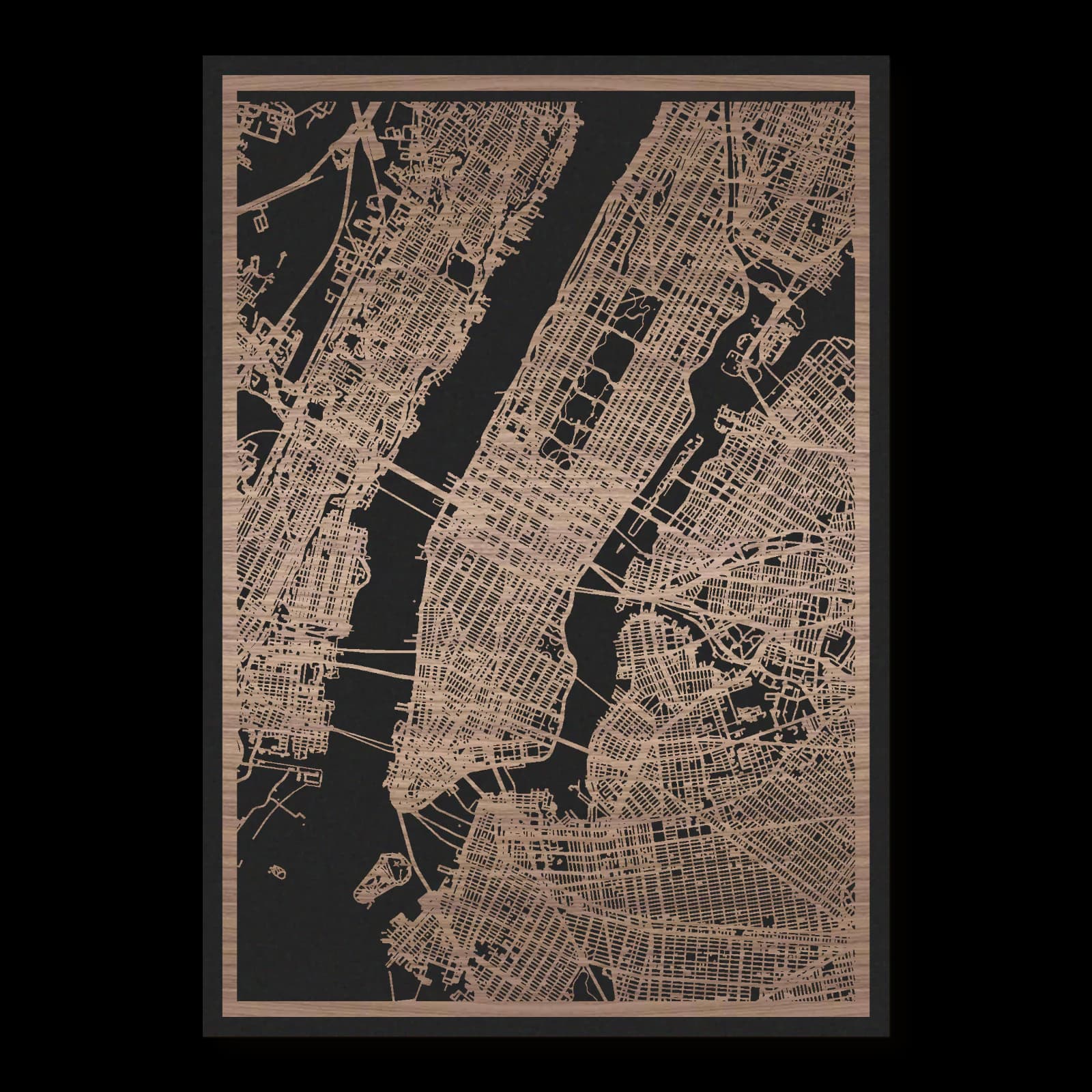
New York.
Layered wooden city map in oiled walnut, portrait format.
About the product
New York appears as a connected landscape of Manhattan and neighbouring waterfront districts. Times Square, Grand Central Terminal, Washington Square and Brooklyn Bridge offer reference points within the dense city, while Central Park creates a substantial opening. This view recalls journeys between the street grid, older neighbourhoods and crossings over water. Portrait format brings the long street grid, Central Park and southern bridges into one view. Oiled walnut gives the cut map a natural surface, with the backing panel lending depth to connections between districts.
What does the map show?
- Times Square
- Brooklyn Bridge
- Central Park
- Grand Central Terminal
- Precisely cut and engraved
- Fine laser details with clear depth
- Carefully inspected and securely packed
- Handmade in Germany
Configuration
Shape: Rectangular · Design: Layered · Material: Walnut · Sizes: 20 × 30 cm, 35 × 50 cm, 50 × 70 cm
The configuration shown in the cart and at the time of ordering is authoritative. The preview is not a dimensioned technical drawing.
Availability & production
- Availability
- Made to order
- Production time
- Ships in 3-5 business days
Production starts after successful payment and complete product configuration.
Materials & care
Depending on the variant, lacquered or oiled MDF or oiled real-wood veneer on MDF; optional stainless-steel mounting screws. Acrylic lacquer spray, hard-wax oil and white glue are used in production.
Wood is a natural material. Grain and color may vary slightly from the product images.
Clean with a dry, soft cloth and protect from prolonged moisture and direct heat.
Included & installation
The selected product in the ordered configuration, securely packed and prepared for installation.
- Maximum dimensions 50 × 70 cm and maximum product weight 2 kg.
- Wall-fixing screws and wall plugs are not included. Use fixings suitable for the wall type, substrate and product weight.
- Installation must be carried out by an adult. Keep optional mounting screws and other small parts away from children until installation.
Shipping & returns
Securely packed shipping. Return and cancellation information is available in the legal section.
Shipping costs and delivery options depend on the destination and format. The published cancellation right applies to non-personalised standard goods; it may be excluded for individually made products.
Manufacturer & product identifier
- Manufacturer
- Benjamin Nöst - Lightworks
Rorichmoorer Str. 76
26802 Moormerland, Deutschland
kontakt@lightworks.de - Product identifier
- LW-CAT-D851F51967FE-S, LW-CAT-D851F51967FE-M, LW-CAT-D851F51967FE-L
Together with the order or production batch, the relevant SKU enables traceability. Safety questions and incidents can be reported to the email address shown above.
Product safety
- Decorative product for dry indoor use only; not a toy and not intended for children.
- Protect from moisture, high heat and open flames.
- Do not continue to hang the product after a fall, breakage or visible damage. Keep damaged parts away from children.
New York: Manhattan and the connections across the water
Manhattan gives this view of New York its strongest direction, but remains closely connected with neighbouring waterfronts. Times Square, Grand Central Terminal, Washington Square, Brooklyn Bridge and Central Park identify different urban settings. Their relationship reveals how grids, older streets, major open spaces and river crossings jointly shape the inner metropolis.
A long island within a larger city
Manhattan has a pronounced lengthwise direction. Water defines its edges, while bridges and other transport connections bind it to neighbouring shores. This overview therefore represents an inner part of the metropolis rather than all five boroughs. Districts across the rivers remain essential to understanding New York, even though Manhattan contains many of its best-known reference points.
Brooklyn Bridge makes that relationship especially clear. Opened in 1883, it links Manhattan and Brooklyn across the East River. Its importance lies in concentrating movement between urban areas as well as in its memorable construction. The bridge setting reveals an island edge that belongs to a broader connected city.
Grid, junction and arrival
Regularly planned streets organise much of Midtown. Times Square occupies a place where Broadway introduces another direction into that pattern. Resulting intersections and open spaces differ from a simple rectangular block. Such departures help people orient themselves within a street system that might otherwise appear repetitive.
Grand Central Terminal establishes a major arrival point farther east. Opened in 1913, it connects railway movement with Manhattan's dense development. The building and its approaches demonstrate how substantial infrastructure can be integrated into a close urban environment. Large flows of people meet the scale of particular streets and entrances.
Farther south, Washington Square creates an opening within a different local street arrangement. The transition towards Midtown shows that Manhattan did not grow everywhere according to the same plan. Earlier routes and later planning coexist within one island, producing recognisably different neighbourhood experiences.
A deliberately created landscape
Central Park was developed in the nineteenth century from the design of Frederick Law Olmsted and Calvert Vaux. Its apparently natural paths, lawns and water bodies belong to a planned landscape. Construction also transformed land that had previously supported homes and other uses. The park is neither a chance survival of empty ground nor a place without an earlier human history.
Its extensive open area contrasts strongly with surrounding buildings. Reading New York becomes more revealing when that contrast is compared with smaller interruptions in the grid. A park, square, station and bridge each create a different relationship between movement and staying in place. Together they help explain how an exceptionally dense city can still be experienced through distinct, memorable spaces whose positions make the wider urban landscape easier to understand.
Sources
- Central Park Conservancy: Park History — https://www.centralparknyc.org/park-history
- Wikipedia: Brooklyn Bridge — https://en.wikipedia.org/wiki/Brooklyn_Bridge
- Wikipedia: Times Square — https://en.wikipedia.org/wiki/Times_Square
- Wikipedia: Grand Central Terminal — https://en.wikipedia.org/wiki/Grand_Central_Terminal
- Wikipedia: Washington Square Park — https://en.wikipedia.org/wiki/Washington_Square_Park

Still deciding?
Configure your motif in the studio and see how your city map will look in your space.