
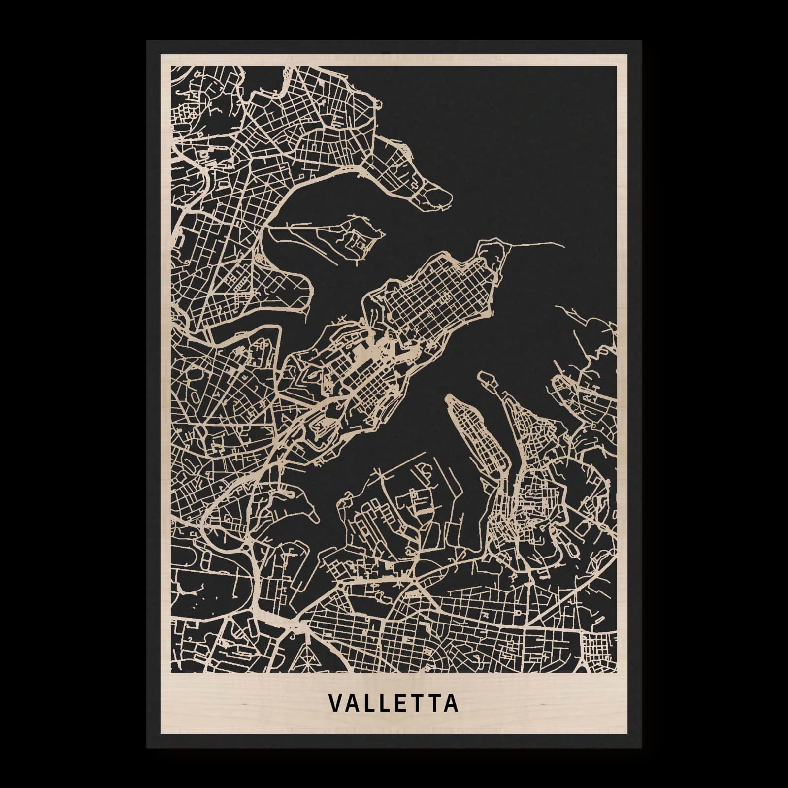
Valletta.Fortified city between two harbours
Rectangular wooden city map made from oiled maple – two layers with a black back plate.
About the product
Valletta occupies a narrow fortified peninsula between two harbours. City Gate, St John’s Co-Cathedral, Upper Barrakka Gardens and Fort St Elmo establish references across its compact urban fabric. Wood gives the street grid, bastion edges and coastline a shared material character. The map connects dense building blocks with the open water landscape that has shaped the city’s position and history.
What does the map show?
- City Gate
- St John’s Co-Cathedral
- Upper Barrakka Gardens
- Fort St Elmo
- Harbour peninsula
- Precisely cut and engraved
- Fine laser details with clear depth
- Carefully inspected and securely packed
- Handmade in Germany
Configuration
Shape: Rectangular · Design: Layered · Material: Maple · Sizes: 20 × 30 cm, 35 × 50 cm, 50 × 70 cm
The configuration shown in the cart and at the time of ordering is authoritative. The preview is not a dimensioned technical drawing.
Availability & production
- Availability
- Made to order
- Production time
- Ships in 3-5 business days
Production starts after successful payment and complete product configuration.
Materials & care
Depending on the variant, lacquered or oiled MDF or oiled real-wood veneer on MDF; optional stainless-steel mounting screws. Acrylic lacquer spray, hard-wax oil and white glue are used in production.
Wood is a natural material. Grain and color may vary slightly from the product images.
Clean with a dry, soft cloth and protect from prolonged moisture and direct heat.
Included & installation
The selected product in the ordered configuration, securely packed and prepared for installation.
- Maximum dimensions 50 × 70 cm and maximum product weight 2 kg.
- Wall-fixing screws and wall plugs are not included. Use fixings suitable for the wall type, substrate and product weight.
- Installation must be carried out by an adult. Keep optional mounting screws and other small parts away from children until installation.
Shipping & returns
Securely packed shipping. Return and cancellation information is available in the legal section.
Shipping costs and delivery options depend on the destination and format. The published cancellation right applies to non-personalised standard goods; it may be excluded for individually made products.
Manufacturer & product identifier
- Manufacturer
- Benjamin Nöst - Lightworks
Rorichmoorer Str. 76
26802 Moormerland, Deutschland
kontakt@lightworks.de - Product identifier
- LW-CAT-1FD0A1D2EC30-S, LW-CAT-1FD0A1D2EC30-M, LW-CAT-1FD0A1D2EC30-L
Together with the order or production batch, the relevant SKU enables traceability. Safety questions and incidents can be reported to the email address shown above.
Product safety
- Decorative product for dry indoor use only; not a toy and not intended for children.
- Protect from moisture, high heat and open flames.
- Do not continue to hang the product after a fall, breakage or visible damage. Keep damaged parts away from children.
Valletta’s planned streets within a fortified peninsula
Founded in 1566, Valletta occupies a hilly peninsula between two natural harbours. Its location explains the close relationship between urban planning and defence. A regular street network lies within pronounced fortified edges. City Gate, the order’s church, Upper Barrakka Gardens and Fort St Elmo introduce different settings from the southwestern entrance towards the northeastern tip.
Foundation and a regular urban pattern
The siege of Malta in 1565 was followed by Valletta’s foundation in 1566. The new city received a planned structure on ground that is not uniformly level. Regular streets consequently meet slopes and changing elevations, creating an important part of its physical character. The grid connects dense blocks, public squares and institutional buildings within a bounded urban area. Fortified margins establish a distinct edge towards the harbours. Settlement and water belong to the same landscape while performing different spatial roles. Understanding both gives the peninsula a clearer identity than considering its principal buildings alone.
Fort St Elmo at the exposed tip
Fort St Elmo occupies the peninsula’s strategic tip. The position already mattered as a watch-post during the medieval period. In the siege of 1565, the fort resisted for approximately a month before falling on 23 June. Subsequent centuries brought additions and incorporation into Valletta’s wider defences. This history explains why the northern end is more than the final point of the street network. It relates to control of the harbour approaches, bringing views over the water together with successive periods of military use and architectural adaptation. Location and historical purpose are particularly closely connected here.
An order’s church in the central city
St John’s Co-Cathedral was constructed as the conventual church of the Knights of St John and completed in 1577. Its dedication to John the Baptist connects the building with the order’s religious identity. The central position differs from the exposed setting of the fort. Worship and institutional representation occupy the densely developed city, surrounded by streets and neighbouring buildings. Their relationship places the church within the everyday fabric of the centre. Large architectural works and relatively compact building blocks share limited ground, demonstrating how different civic and religious purposes were accommodated within the planned settlement.
Entrance, gardens and waterside boundaries
Renzo Piano’s present City Gate project treats the entrance alongside new public and architectural spaces. It adds another phase to a city whose established structure has continued to be used and changed. Near the southern fortified edge, Upper Barrakka Gardens provide a green reference beside the harbour landscape. Their setting has a different relationship with water from the fort at the tip. Connected streets and squares occupy the ground between them. Valletta consequently appears as a compact planned city with a continuing architectural history, shaped together by dense development, differences in elevation, defensive boundaries and the adjoining harbour spaces.
Sources
- City of Valletta - UNESCO World Heritage Centre — https://whc.unesco.org/en/list/131/
- The Co-Cathedral — https://www.stjohnscocathedral.com/the-co-cathedral/
- Fort St Elmo and the National War Museum - Heritage Malta — https://heritagemalta.mt/explore/fort-st-elmo-national-war-museum/
- La Valletta City Gate - Renzo Piano Building Workshop — https://www.rpbw.com/project/la-vallete-city-gate
- Heritage Malta: Valletta 1566 und historisches Straßengitter — https://heritagemalta.mt/news/valletta-1566-melita-renascens/

Still deciding?
Configure your motif in the studio and see how your city map will look in your space.