
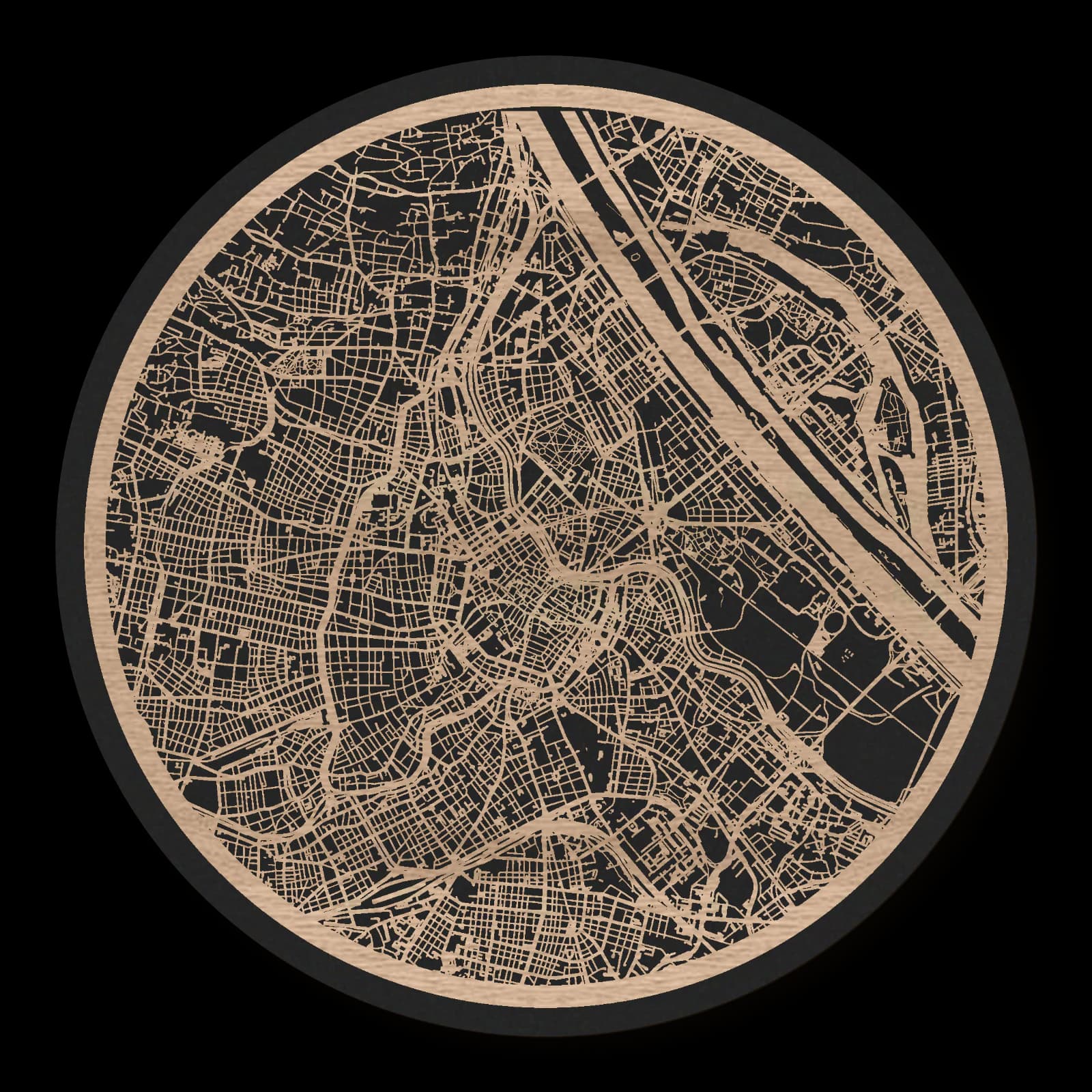
Vienna.Inner city, Prater and Belvedere
Round wooden city map made from oiled oak – two layers with a black back plate.
About the product
Close old-town streets, grand grounds and broad green spaces shape inner Vienna. From St Stephen's Cathedral, the map reaches south to Belvedere, northeast to the Prater and west to Westbahnhof. Its fine connections and larger urban avenues gain a quiet warmth in wood. The historic centre sits within a wider composition of neighbourhoods that developed in different ways.
What does the map show?
- St Stephen’s Cathedral at the centre
- Belvedere Palace to the south
- Prater and Giant Ferris Wheel
- Westbahnhof and western districts
- Precisely cut and engraved
- Fine laser details with clear depth
- Carefully inspected and securely packed
- Handmade in Germany
Configuration
Shape: Round · Design: Layered · Material: Oak · Diameter: Ø 23 cm, Ø 35 cm, Ø 50 cm
The configuration shown in the cart and at the time of ordering is authoritative. The preview is not a dimensioned technical drawing.
Availability & production
- Availability
- Made to order
- Production time
- Ships in 3-5 business days
Production starts after successful payment and complete product configuration.
Materials & care
Depending on the variant, lacquered or oiled MDF or oiled real-wood veneer on MDF; optional stainless-steel mounting screws. Acrylic lacquer spray, hard-wax oil and white glue are used in production.
Wood is a natural material. Grain and color may vary slightly from the product images.
Clean with a dry, soft cloth and protect from prolonged moisture and direct heat.
Included & installation
The selected product in the ordered configuration, securely packed and prepared for installation.
- Maximum dimensions 50 × 70 cm and maximum product weight 2 kg.
- Wall-fixing screws and wall plugs are not included. Use fixings suitable for the wall type, substrate and product weight.
- Installation must be carried out by an adult. Keep optional mounting screws and other small parts away from children until installation.
Shipping & returns
Securely packed shipping. Return and cancellation information is available in the legal section.
Shipping costs and delivery options depend on the destination and format. The published cancellation right applies to non-personalised standard goods; it may be excluded for individually made products.
Manufacturer & product identifier
- Manufacturer
- Benjamin Nöst - Lightworks
Rorichmoorer Str. 76
26802 Moormerland, Deutschland
kontakt@lightworks.de - Product identifier
- LW-CAT-C3A8D764DB36-S, LW-CAT-C3A8D764DB36-M, LW-CAT-C3A8D764DB36-L
Together with the order or production batch, the relevant SKU enables traceability. Safety questions and incidents can be reported to the email address shown above.
Product safety
- Decorative product for dry indoor use only; not a toy and not intended for children.
- Protect from moisture, high heat and open flames.
- Do not continue to hang the product after a fall, breakage or visible damage. Keep damaged parts away from children.
Vienna’s historic centre and wider open spaces
Vienna combines a compact older core with substantial grounds and later urban extensions. St Stephen’s Cathedral, Belvedere, the Prater and Westbahnhof mark very different settings within that relationship. Their distribution reveals how the city grew beyond its earlier boundaries, connecting historic, representative and everyday urban spaces in a continuous built landscape.
The older centre around the cathedral
St Stephen’s Cathedral stands within a closely organised network of streets in central Vienna. The older city contains smaller sequences of spaces and less regular connections than many later districts. The cathedral provides a strong point of reference, while its surroundings depend on the close association of different streets and squares. Within the wider city, this core remains a recognisable historical layer. Later routes and neighbourhoods surround it without removing its internal character. Comparing it with places farther out makes the compact scale of the older centre particularly clear.
A nineteenth-century transformation
The decision in 1857 to remove the fortifications opened new possibilities for Vienna’s development. The Ringstrasse created generous space for movement, public institutions and representative architecture. This transformation connected the older centre more closely with the surrounding city. It also expressed civic and imperial ambitions through substantial institutional buildings. In the urban plan, the change of scale is especially important. Broader streets and larger complexes followed the tighter historic fabric. A former boundary consequently became a new connection within the expanding city, reshaping the relationship between central Vienna and its neighbouring districts.
Different open spaces at Belvedere and Prater
Belvedere Palace stands south of the historic centre, forming a distinct ensemble with its gardens. To the northeast, the Prater and its Giant Ferris Wheel introduce another kind of open area. Both differ from the densely built core, but they also differ from each other. Formal palace grounds follow different spatial principles from a large historic leisure district. Their positions within the expanded city show that open areas are active parts of urban structure. They provide substantial reference points around which surrounding neighbourhoods developed, rather than simply occupying leftover ground between buildings.
Western connections and the everyday city
Westbahnhof establishes a transport focus west of the historic centre. Dense residential and commercial districts lie between it, the cathedral, Belvedere and the Prater. These neighbourhoods connect familiar landmarks into an everyday city. The wider view consequently contains several kinds of centre: a medieval core, representative grounds, a large leisure area and a railway station. Vienna’s continuity emerges through their connection. Different scales and periods remain visible, while streets and intervening districts draw the separate focal points into a coherent urban area extending beyond the limits of the historic centre.
Sources
- WienTourismus: Entstehung der Ringstraße — https://www.wien.info/de/kunst-kultur/ringstrasse/entstehung-der-ringstrasse-345188
- WienTourismus: Ringstrasse — https://www.wien.info/en/art-culture/architecture/ringstrasse-356762
- WienTourismus: Important Buildings on the Ringstrasse — https://www.wien.info/en/art-culture/ringstrasse/most-important-public-buildings-352268
- WienTourismus: Prater Nostalgia — https://www.wien.info/en/see-do/prater/prater-nostalgia-355702

Still deciding?
Configure your motif in the studio and see how your city map will look in your space.